WHAT IT IS
EKS «Купол» (Kupol, "Dome") is Russia's current space-based missile-launch detection system. The formal name of the programme is Единая космическая система (ЕКС, EKS), "Unified" or "Integrated Space System"; its military index is 14К032; the satellites in highly elliptical orbit are called «Тундра» (Tundra) and carry the index 14Ф142. "Kupol" was publicly attached to the system by officials only around December 2019. The system's job is simple to state: see the hot exhaust plume of a ballistic missile or space rocket within seconds of launch, from orbit, and tell the ground. [DOCUMENTED for names and indices as reported by Hendrickx and RussianSpaceWeb; SINGLE-SOURCE for the exact date the name Kupol became public]
Two details on the designations deserve attention, because online copy mixes them up:
The system supplements, and in part replaces, the Soviet-era Око (Oko) satellites US-K and US-KMO. It feeds the missile-attack warning centre at Solnechnogorsk (see Solnechnogorsk SPRN), which also receives the ground-radar layer from Voronezh, Dnepr, Daryal, Volga and other radars. From there the warning goes to the General Staff and the senior leadership (see NDMC, Kazbek, Perimeter).
Note on the picture above: this is a generic computer-generated render of a satellite over Earth's cloud cover, not a photograph of an EKS/Tundra satellite and not an official image. No photograph of a Tundra satellite in orbit has been published; the one image the developer released in 2017 and several exploded-view drawings from Kometa are the only public views of the hardware (see the hardware section below). [DOCUMENTED]
HOW TO READ THIS PAGE
Every statement carries one of four labels.
Satellite system details are mostly from the specialist work of Bart Hendrickx (The Space Review, February 2021) and Anatoly Zak (RussianSpaceWeb); dates in this article's launch table are from RussianSpaceWeb and cross-checked against the Kosmos designation lists. Russian terms are given in Cyrillic with transliteration. The page was written in October 2026; a later change of constellation status is possible.
WHAT IT IS FOR
The purpose of EKS is early warning of ballistic-missile attack and a general watch on missile and space launches worldwide. In more detail the published and inferred tasks are:
What it is not: it is not a weapon, not an imaging reconnaissance satellite (the sensor is a missile-plume sensor), and not the thing that authorises anything. It provides one input to a human and automated assessment chain. The decision logic, the two-phase confirmation (space cue, then radar confirmation) and the leadership procedure are discussed in the Solnechnogorsk article.
THE TWO-LAYER BARRIER IN ONE PICTURE
RussianSpaceWeb describes the EKS constellation as the first line of a two-layered virtual barrier around Russian borders: the satellites in space, plus the ground-based radar installations across the country and a control centre. That framing matches the one the Ministry of Defence used in a December 2019 briefing, in which the space-based and ground-based elements of the early-warning network were presented together. [DOCUMENTED / SINGLE-SOURCE]
| Layer | Main elements | What it sees | Typical role |
|---|---|---|---|
| Space layer | EKS/Tundra (HEO), later GEO; Oko legacy | Infrared plume at launch, hundreds to thousands of km from the target | First cue, within seconds of launch |
| Ground-radar layer | Voronezh-M/DM/VP, Dnepr, Daryal, Volga, Container over-the-horizon | Warheads and missile stages as they rise over the radar horizon | Confirmation, accurate trajectory, impact prediction |
| Fusion and command | Main Missile Attack Warning Centre (Solnechnogorsk), Serpukhov-15 control, General Staff, NDMC | Everything above, correlated | Assessment and reporting |
| Response | Kazbek / Cheget, Perimeter, A-135 | Orders and alerts | Decision and engagement |
WHY LOOK FROM SPACE — THE WARNING-TIME ARGUMENT
A long-range ballistic missile has three phases:
A ground radar can only see what rises above its horizon. A radar on the ground sees an object at altitude h out to a line-of-sight distance of about √(2·R·h), where R is Earth's radius (6,371 km). For a warhead at 1,000 km altitude that is about 3,600 km; at 300 km it is about 1,960 km. So a radar on the coast sees the warhead only after it has been flying for many minutes. In practice, strategic early-warning radars (Voronezh class: stated detection range about 6,000 km against typical targets; Dnepr/Daryal: similar order) get the first sighting some 10–20 minutes before impact for an intercontinental trajectory, with the exact number depending on the geometry. [ESTIMATE; see the Voronezh article for the radar figures]
A satellite sees the plume from above at once, with line of sight to the launch site, no matter how far away. That is why every nuclear power that has an early-warning system has satellites: the satellite can hand the defence a cue in seconds, giving up to about 10–20 additional minutes of notice for land-based ICBMs. Hendrickx adds an important caveat: for submarine-launched missiles fired close to the target, such as from the Atlantic, satellites add little, because the missile's flight time is itself only 10–15 minutes and radars see it nearly as soon. [DOCUMENTED / ESTIMATE]
What the satellite cue buys in practice
None of this is secret physics; the numbers are the reason the layered design is universal. [ESTIMATE]
WHAT WAS BEFORE EKS — OKO
The first generation: US-K
Soviet work began in the early 1960s on early-warning satellites; plans for low-orbit satellites were dropped in favour of a constellation in highly elliptical orbits (HEO). The first launch was in 1972. The satellites, designated US-K (УС-К) and named Око (Oko, "Eye"), flew in orbits like those of the Molniya communications satellites but arranged so that they could watch the US ICBM fields from the apogee over the northern Atlantic. Their sensors could not reliably see a plume against an illuminated Earth, so they watched at a grazing angle: the missile was seen against the dark background of space as soon as it rose above the horizon. [DOCUMENTED]
The price of that geometry was vulnerability to the Sun: when the Sun was setting behind the Earth's limb in the satellite's view, sunlight could be reflected from high clouds into the sensor. This produced the best-known false alarm of the Cold War (see the 1983 section below). [DOCUMENTED]
The second generation: US-KMO
US-KMO (УС-КМО; the geostationary type) was introduced in 1991 with the aim of global coverage from geostationary orbit, including the ability to see launches against the background of Earth and to see submarine-launched missiles. In practice, many satellites failed early; reports claim the sensors performed below expectations; the type had spotty coverage and a short career. The last satellites of the old system were Kosmos-2469 (30 September 2010) and Kosmos-2479 (30 March 2012) in the Wikipedia record; Hendrickx writes that following the retirement of the final first- and second-generation satellites in 2014 Russia's early-warning network was left without any operational satellite. [DOCUMENTED / SINGLE-SOURCE]
1983: the Petrov incident, in two paragraphs
On 26 September 1983, the Soviet ground control station at Serpukhov-15 received an alarm that the Oko satellites had detected launches from US missile fields. The duty officer, Lt-Col Stanislav Petrov, judged it a false alarm — among his reasons: only a handful of missiles reported, whereas a US attack would be expected to be massive; and the ground radars had not corroborated. The cause was later attributed to sunlight reflecting from high-altitude clouds as seen from the satellite's grazing viewing angle. [DOCUMENTED]
The lesson is encoded in everything EKS does differently: orbit geometry that spreads the viewing angle, spectral filtering to reject reflected sunlight, multiple satellites seeing the same event, and a deliberate ground-radar corroboration step. As Hendrickx notes, the alarm could just as easily have been called off higher up the chain "in the absence of corroborative data from ground-based early warning radars." [DOCUMENTED / ESTIMATE] A deeper article on the incident is a candidate for its own page (see gaps in the report).
THE LONG ROAD TO EKS — PROGRAMME HISTORY
| Year | Event | Label |
|---|---|---|
| 1999 | Plans announced for a new constellation of HEO and GEO satellites called EKS | [DOCUMENTED] |
| 15 March 2002 | Kometa receives the EKS contract from the Ministry of Defence | [DOCUMENTED] |
| 18 March 2004 | Kometa chooses RKK Energia (the former Korolev design bureau) as satellite builder | [DOCUMENTED] |
| Original schedule | First HEO and GEO launches announced for 2007 and 2009; the network was said to be ready by 2005 in earlier plans | [DOCUMENTED] |
| 2011 | Defence Ministry sues Energia for the delay; the Ministry loses the case | [SINGLE-SOURCE; Kommersant via Wikipedia] |
| April 2012 | Contract to manufacture the satellites reported signed | [SINGLE-SOURCE] |
| 2014 | The last Oko satellites retire; Russia has no operational early-warning satellite | [DOCUMENTED / SINGLE-SOURCE] |
| 17 Nov 2015 | First launch, Kosmos-2510 | [DOCUMENTED] |
| May 2020 | Fourth satellite; "minimum baseline configuration" announced | [DOCUMENTED] |
| 2 Nov 2022 | Sixth Tundra, Kosmos-2563 | [DOCUMENTED] |
Why so long? Open sources point to technical problems with the payload (unofficial reports of continuing problems with the "sophisticated payloads"), changing specifications from the customer (the Energia position in the lawsuit), subcontractor problems, post-2014 sanctions on electronics, and the failure of the only other geostationary satellite on RKK Energia's UKP platform (AngoSat-1, December 2017, a power failure days after launch). [SINGLE-SOURCE]
Energia's platform heritage matters. The Tundra bus derives from the Yamal communications satellites, i.e. a commercial-heritage, unpressurised design — unlike the pressurised Soviet-era early-warning buses. [DOCUMENTED; Zak and Hendrickx]
HOW KUPOL FITS WITH THE RADAR NETWORK
The simplest correct picture of the Russian missile-attack warning system is a stack of two sensor layers feeding one assessment centre. Neither layer is the system on its own:
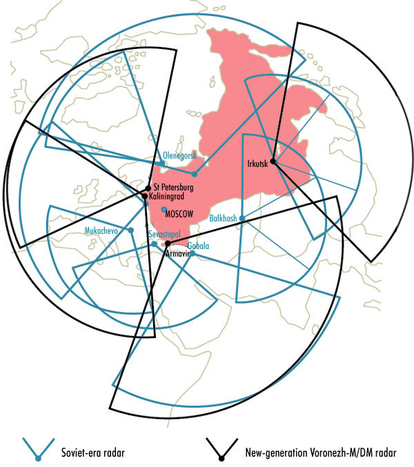
The user-supplied map below shows the ground-radar layer: the Soviet-era radar sectors (blue) and the new-generation Voronezh-M/DM sectors (black), with their named sites. It is included here to show what the satellites are layered on top of, not as a Kupol coverage map.
Reading the map
The map's own legend identifies two sets of sectors. Sites labelled on the map: [DOCUMENTED from the map labels]
| Sector colour | Sites labelled on the map | Notes |
|---|---|---|
| Soviet-era radar (blue) | Olenegorsk, Mukachevo, Sevastopol, Gabala, Balkhash | Olenegorsk (Kola Peninsula) is in Russia; Mukachevo (Ukraine), Sevastopol (Crimea), Gabala (Azerbaijan) and Balkhash (Kazakhstan) were Soviet-era sites outside today's Russian mainland. Sectors are drawn as wedges with a fixed azimuth width and a maximum range |
| New-generation Voronezh-M/DM (black) | St Petersburg, Kaliningrad, Armavir, Irkutsk | Voronezh-type stations near these places; the wedge shows the surveyed sector, not an exact detection-range boundary |
What the map shows at a glance, and what to take from it: [ESTIMATE as interpretation]
The division of labour in plain language
Imagine a burglar alarm. The radars are the motion sensors on the doorways: very accurate, but they only trigger when someone is already at the door. The satellites are the cameras on the street: they spot someone approaching long before they reach the door, but they can be fooled by a shadow. A sensible alarm panel waits for the second signal before it rings the bell. The Russian system works like that: the satellite cue starts the assessment; the radar confirmation completes it. [ESTIMATE as analogy]
| Question | Satellite layer says | Radar layer says | Fusion decides |
|---|---|---|---|
| Has something been launched? | Yes — plume seen at time T from region X | Not yet visible | Pending: "launch detected, unconfirmed" |
| Is it a missile and how many? | Count of plumes; brightness | Count of objects once they rise | Confirm count and class |
| Where will it hit? | Rough trajectory from boost-phase data | Precise track from several minutes of radar data | Impact points and time |
| Could it be a false alarm? | Cloud-top glint, fire, sun angle — possible | Radar clutter, aircraft, ionosphere — possible | A false alarm in both at once is unlikely |
| How much time is left? | Estimate from launch time | Estimate from track | Report to leadership |
Where the fusion happens
The assessment is made at the Main Centre for Missile Attack Warning (ГЦ РПН, Главный центр предупреждения о ракетном нападении) at Solnechnogorsk. The command and control of the satellites themselves is exercised from the Western Control Station (ЗМКП) at Serpukhov-15 (Kurilovo, about 70 km south-west of Moscow), where two separate ground-control stations about a kilometre apart used to handle the HEO and the GEO satellites; both were upgraded for EKS and together referred to as Object 455/E (see Serpukhov-15). An Eastern Control Station (ВМКП), Object 485, near Gaiter (Khabarovsk Region) in the Far East was built for the second-generation satellites and was being modified for EKS as Object 485/E, with work reported not yet completed in the documents Hendrickx saw. [DOCUMENTED / SINGLE-SOURCE]
| Node | Role | Link in this article |
|---|---|---|
| Solnechnogorsk (Main Centre for Missile Attack Warning) | Fusion and assessment; sends the warning upward | sprn-solnechnogorsk |
| Serpukhov-15 (Western Control Station, Object 455/E) | Command and control and data reception for the satellites | serpukhov-15 |
| Gaiter, Khabarovsk Region (Eastern Control Station, Object 485/E) | Planned eastern control for Pacific-facing satellites | [SINGLE-SOURCE] |
| Voronezh / Dnepr / Daryal / Volga / Container radars | Ground-radar layer | voronezh, dnepr, 29b6-container |
| General Staff, NDMC | Consumers of the warning picture | ndmc |
| Kazbek / Cheget | Leadership communications | kazbek |
| Perimeter | Last-resort automatic command system | perimeter-dead-hand |
| A-135 / Don-2N | Moscow missile defence, a consumer of cueing | don2n, a135-a235-nudol |
What Kupol replaces, and what it does not
It replaces Oko. The EKS constellation is the replacement for the US-K and US-KMO satellites of the Oko programme. [DOCUMENTED]
It does not replace the radars. Hendrickx wrote that the relatively sluggish pace of the EKS programme may be a sign that the satellites take a backseat to the ground-based network, and that the main benefit of the satellites is spotting missiles before they enter radar visibility; in some scenarios, such as a submarine launch in the Atlantic, they add little warning time. In other words, the satellites supplement the radars. They also serve as intelligence tools collecting data on foreign weapon activity and tests. [DOCUMENTED / SINGLE-SOURCE]
Seen from the top: the chain of consumers
THE ORBIT — HOW A MOLNIYA-TYPE ORBIT WORKS
The Tundra satellites fly in Molniya-type orbits, i.e. highly elliptical, inclined about 63–64°, with a period of about 12 hours. The orbital elements of the first satellite (Kosmos-2510), from NORAD data quoted by RussianSpaceWeb, were: [DOCUMENTED]
| Element | Value (Kosmos-2510, first day) |
|---|---|
| Inclination | 63.788° |
| Argument of perigee | about 270° |
| Period | 11 h 54 min 11 s |
| Perigee altitude | 1,626 km |
| Apogee altitude | 38,552 km |
Name check: "Tundra orbit" is not the orbit Tundra uses
The name Тундра belongs to the satellite. In astronautics a "Tundra orbit" is a different, 24-hour elliptical orbit (inclined 63.4°, used by some radio-broadcast satellites) that makes one loop per sidereal day and appears to hover over one longitude. EKS/Tundra satellites do not use that. They use 12-hour Molniya-type orbits with two apogees per day over two different longitudes. [DOCUMENTED]
The arithmetic, step by step
Kepler's laws give the orbit's size from the period, and the speed from the size. With Earth's radius 6,378 km and the standard gravitational parameter μ = 398,600 km³/s²:
Why 63.4° (the critical inclination)
An orbit around a flattened Earth precesses: the long axis (the line from perigee to apogee) slowly rotates, because Earth's equatorial bulge pulls on the satellite. At an inclination of about 63.4° (and its mirror 116.6°) the rotation of the apsides drops to nearly zero. This is the "critical inclination". Without it, the perigee would drift to the equator-side within months and the apogee would end up over the southern hemisphere; with it, the apogee stays parked over the north for years, with only small corrections. The inclination is slightly above critical in the published elements (63.8°), which is consistent with deliberate choices of other perturbations (Moon and Sun) and the ground track the operators want. [ESTIMATE; standard orbital mechanics]
Dwell time — why the satellite "hovers"
Kepler's second law says a satellite sweeps equal areas in equal times, so it spends most of its time far from Earth. Using the elements above, the satellite spends approximately: [ESTIMATE; computed from Kepler's equation]
| Portion of orbit | Time spent | Altitude range |
|---|---|---|
| Within ±30° of apogee (true anomaly) | about 6.7 hours | above about 27,900 km |
| Within ±60° of apogee | about 9.6 hours | above about 14,500 km |
| Within ±90° of apogee | about 10.8 hours | above about 7,200 km |
So each 12-hour orbit gives roughly 6–7 hours of high, slow dwell near apogee. Hendrickx says the satellites spend "several hours hovering high above the Northern hemisphere" at each apogee.
Two apogees per day: Greenland and the Far East
Because the period is half a day and the Earth rotates once in that time, the ground track repeats every 24 hours with two apogees at longitudes 180° apart. For EKS, Hendrickx places one approximately over Greenland and the other above Russia's Far East. RussianSpaceWeb says the first satellite makes one long pass over Western North America, and another six hours later over Eastern China and Russia, then swings quickly over the Pacific and Indian Oceans in the low part of the orbit. [DOCUMENTED / SINGLE-SOURCE]
The two apogees have different jobs: [ESTIMATE]
A satellite at apogee sees most of a hemisphere
From a radius of 44,930 km the Earth's disc subtends an angle of 2 × asin(6,378 / 44,930) = about 16.3° across. That is the satellite's entire field of regard for the Earth: a telescope with a 16° field of view sees the whole visible disc at once. From geostationary altitude (42,164 km radius) the disc is 17.4° across. This is why one narrow-angle and one wide-angle channel suffice: the wide channel stares at the region of interest (North America, say), the narrow channel zooms onto a detected event. [ESTIMATE]
At perigee (radius 8,004 km) the disc is about 106° across, but the satellite is moving fast and far from useful viewing geometry; the system operates at the high part of the orbit only.
The viewing-angle problem the orbit solves
The Soviet satellites were designed to look across the limb: from an apogee over the Atlantic, a launch from the US plains is seen at a grazing angle, against space beyond the horizon. That geometry avoids a bright Earth background but raises another problem: sunlight reflected from clouds near the limb. The modern design has a different position (apogee farther west, over Greenland) and a sensor designed to look down through the atmosphere at a more favourable angle, relying on spectral and temporal filtering (see below). [ESTIMATE — how the sensor is actually pointed is unpublished] The Russian developer's chief says the HEO satellites can see launches from both the American continent and the oceans. [SINGLE-SOURCE]
Perturbations and station-keeping
Even at critical inclination, Molniya-type orbits are disturbed by the Moon and the Sun and by Earth's oblateness. The satellites carry electric thrusters (see hardware section) to counter this, and have their own propulsion for orbit adjustments. NORAD data show the first satellite raised its apogee by about 30 km on 3 December 2015 and by about 60 km between 4 and 5 December 2015. [DOCUMENTED / SINGLE-SOURCE]
Radiation exposure
Each loop crosses the Van Allen radiation belts twice. A Molniya orbit goes through the heart of the inner and outer belts every orbit. This is why the design lifetime of the HEO satellites is quoted at 7.5 years minimum, shorter than the 12.5 years quoted for geostationary ones: dose accumulates. Solar-array degradation, electronics upsets and detector damage are the expected life-limiters. [SINGLE-SOURCE / ESTIMATE]
HOW MANY SATELLITES AND WHAT THEY COVER
A single Molniya-type satellite is useful for 6–7 hours out of each 12; to watch one region continuously you need several in the same ground track, phased in time. The Soviet HEO system flew up to nine satellites simultaneously. For EKS, the Ministry of Defence stated in November 2015 that the ultimate goal was a constellation of ten HEO satellites (a number repeated by a handful of other sources); Hendrickx notes that this number excludes the geostationary satellites, and that ten would prevent gaps in coverage due to the loss of a single satellite and reduce the risk of false alarms by simultaneously monitoring the same area from different satellites. [DOCUMENTED / SINGLE-SOURCE]
After the fourth launch (May 2020) the constellation was said to have reached its "minimum baseline configuration" — four satellites providing round-the-clock cover of the most critical areas, per RKK Energia's general director. The fifth (November 2021) and sixth (November 2022) satellites bring the total to six launched. Whether all six are operational is not independently confirmed in open sources I could check; Wikipedia lists all six as active. [DOCUMENTED / SINGLE-SOURCE]
Two or more satellites seeing the same event is the best defence against false alarms: the same cloud glint will not appear at the same place in two sensors at different viewing angles at the same moment. [ESTIMATE]
THE SATELLITE — HARDWARE
Who built what
| Element | Maker | Notes | Label |
|---|---|---|---|
| System prime contractor, payload oversight | TsNII Kometa (ЦНИИ «Комета»; "Kometa Corporation" since 2012) | Led overall EKS development and supervised the main infrared telescope | [DOCUMENTED] |
| Spacecraft (14Ф142, bus) | RKK Energia (РКК «Энергия») | Universal Space Platform (УКП) / «Виктория» (Viktoria), derived from the Yamal bus | [DOCUMENTED] |
| Structure, honeycomb panels, radiators | NPO Lavochkin | Court documentation as read by Hendrickx | [SINGLE-SOURCE] |
| Electric thrusters | OKB Fakel | SPD-100 Hall-effect thrusters | [SINGLE-SOURCE] |
| Navigation (ASN) antennas | Yaroslavl Radio Factory | For orbit determination | [SINGLE-SOURCE] |
| Cryogenic cooler | KB Tochmash (Nudelman) | Two Stirling cryocoolers and an argon cryostat; tested on the second Tundra | [SINGLE-SOURCE; patent and press release] |
| Onboard processing and protected links | NPO Impuls | Systems 15Е1827, 14Р735, 15Н1953 mentioned in documentation | [SINGLE-SOURCE] |
| Optical payload items | LOMO, NPO Orion, NPP Pulsar, RNII Elektrostandart, NII OEP | Listed as possible contractors | [SINGLE-SOURCE] |
| Ground processing at Plesetsk | Spetsstroi | Clean-room and fuelling wing completed June 2015 | [DOCUMENTED] |
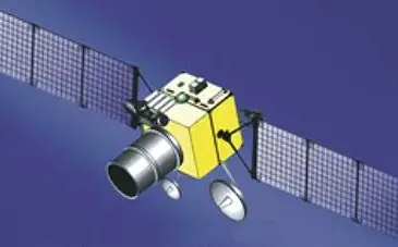
The sketch above is an artist-style drawing in the form of a box-shaped body, two three-section solar wings, a large telescope barrel and several dish antennas. It matches the general arrangement shown in the Kometa drawings (a telescope in a large sun-shade, solar wings, dish antennas). It is a sketch, not a photograph or an engineering drawing, and it does not identify itself as Tundra. [DOCUMENTED as to what the sketch shows; its link to Tundra is ESTIMATE]
The bus: Viktoria / UKP
The УКП / Виктория (Universal Space Platform) is a three-axis-stabilised bus that can be tailored for sun-synchronous, highly elliptical and geostationary orbits. Unlike Soviet satellites, it does not use a pressurised compartment to keep the electronics in a controlled environment: all systems are designed to work in vacuum. Dry mass of the bus is 950–1,200 kg; payload mass is 500–1,000 kg for HEO satellites (250–300 kg for GEO). The stated design life is at least 7.5 years for HEO and up to 12.5 years for GEO. [DOCUMENTED / SINGLE-SOURCE]
Zak's RussianSpaceWeb notes, if Tundra follows the Yamal pattern, it could have four pairs of ion thrusters for attitude control and heat-pipe radiators, and it would be fully unpressurised. [ESTIMATE]
Power
Power comes from deployable solar arrays and batteries. In 2015 RKK Energia described a three-section solar panel more than 9.5 m long, 13.25 m² in area and 58.5 kg in mass, powering satellites of 12–15 years' projected life; the company presentation showed a generic observation satellite with a pair of such panels. Whether Tundra carries exactly that array is not confirmed. [DOCUMENTED for the panel; ESTIMATE for the link]
A back-of-envelope check: 13.25 m² of triple-junction cells at about 28% efficiency, with a solar constant of about 1,360 W/m² at normal incidence, produces about 13.25 × 1,360 × 0.28 ≈ 5 kW per panel at beginning of life (less with packing factor, temperature, and degradation; roughly 3–4 kW usable, ×2 for a pair). The figure is plausible for a HEO satellite with a power-hungry cryocooler, processors and transmitters, but nothing is published. [ESTIMATE]
Batteries are needed for the eclipses. A Molniya orbit with its apsidal line near the critical inclination has seasonal eclipses; at perigee the satellite is deep in Earth's shadow only in certain seasons; the satellite also crosses the radiation belts twice per orbit, requiring radiation-hardened electronics and solar cells with generous cover glass. [ESTIMATE]
Attitude control
Documentation links the service module to star trackers and reaction wheels (index 14С022, "combined engine unit"). In plain terms: a star tracker photographs the star field and computes which way the satellite is pointing, to a few arcseconds; reaction wheels (spinning flywheels) turn the satellite by exchanging angular momentum without using propellant; thrusters "dump" the momentum that accumulates. For a telescope that must point to a fraction of the field of view at a region of Earth 38,000 km away, pointing stability is the master specification. The satellite must also keep its sun-shade pointed away from the Sun and its radiators facing cold space. [SINGLE-SOURCE for the equipment; ESTIMATE for the description]
Propulsion and station-keeping
The Fakel SPD-100 Hall thruster is a 3.5 kg engine with 83 millinewtons thrust and a specific impulse of 1,600 s. Compare that with a chemical engine at 300 s: Hall thrusters use about five times less propellant for a given velocity change but give a tiny force — 83 mN is the weight of a small coin. They work for hours at a time and they are used to counter the Moon, Sun and Earth-oblateness perturbations of the Molniya orbit. The satellite also has its own larger propulsion for orbit adjustments after separation from Fregat. [SINGLE-SOURCE]
The exploded view — transcribed
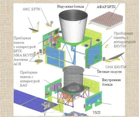
This exploded diagram was published by Kometa in August 2019 (as described by RussianSpaceWeb); Kometa did not explicitly label it as Tundra, but Hendrickx and Zak both treat the drawings as the payload module of the Tundra satellites. [DOCUMENTED for the source; SINGLE-SOURCE for the identification]
The labels visible in the diagram, transcribed from the image: [DOCUMENTED from the picture]
| Label as printed | Meaning (best reading) | Label |
|---|---|---|
| Наружная бленда | Outer baffle / sun-shade (the large white truncated cone on top) | [DOCUMENTED] |
| Внутренняя бленда | Inner baffle (the dark mesh-like tube in the lower section) | [DOCUMENTED] |
| АФАР БРТК | Active phased-array antenna of the BRTK (on-board radio-technical complex) | [DOCUMENTED; AFAR = active phased antenna array] |
| АФС БРТК | Antenna-feeder system (dish and feed) of the BRTK | [ESTIMATE for the expansion] |
| Приборная панель с аппаратурой БРТК | Instrument panel carrying BRTK equipment | [DOCUMENTED] |
| Приборная панель с аппаратурой БКУПИ | Instrument panel carrying BKUPI equipment | [DOCUMENTED] |
| МНА БКУПИ | BKUPI low-gain antenna (Hendrickx: low-gain antennas of the BKUPI) | [SINGLE-SOURCE; expansion ESTIMATE] |
| ОНА БКУПИ | BKUPI high-gain / directional antenna (the dish at right) | [SINGLE-SOURCE; expansion ESTIMATE] |
| Антенны АСН | Navigation-satellite (GLONASS/GPS) receiver antennas | [DOCUMENTED] |
| Тяговые модули | Thruster modules (the Hall-effect thrusters) | [DOCUMENTED] |
| Приборная панель с аппаратурой БАО | Instrument panel carrying BAO equipment (on-board detection equipment) | [DOCUMENTED] |
| УКП | Universal Space Platform (service module) — the label at the bottom | [DOCUMENTED] |
Expansions of the abbreviations. БРТК = бортовой радиотехнический комплекс (on-board radio-technical complex) and БКУПИ = бортовой комплекс управления и передачи информации (on-board control and data-transmission complex) are my reading; Hendrickx glosses them as the "On-Board Radio Communications System (BRTK)" and the "On-Board Control and Data Transmission System (BKUPI)". БАО = бортовая аппаратура обнаружения (on-board detection equipment) per Hendrickx. АСН = аппаратура спутниковой навигации. The abbreviations МНА and ОНА are not expanded in the sources I found; the readings "low-gain" and "high-gain" come from Hendrickx's description of the antennas, and the picture shows a small dish at left and a large dish at right. [SINGLE-SOURCE / ESTIMATE]
Reading the exploded view
Baffles — why the telescope has a long "chimney"
Light from the Sun and from the bright Earth limb must never reach the detector except through the telescope aperture's intended field of view. A baffle is a tube with black, sharp-edged ribs: light from outside the field of view hits the ribs and the dark wall and is absorbed or scattered away before it reaches the optics. The longer and more ribbed the baffle, the smaller the angle off the boresight at which stray light is rejected (the "exclusion angle"). In an early-warning telescope the exclusion angle to the Sun is a key design number, because the Sun is a trillion times brighter than a missile plume. The two baffles in the picture (outer and inner) indicate the designers spent mass on this problem. [ESTIMATE; standard optical engineering]
THE PAYLOAD — HOW THE TELESCOPE WORKS
What is named
The detection payload is called the On-Board Detection Equipment (БАО). It occupies both sections of the payload module with the sun shade on top. Nothing has been officially revealed about its nature, but procurement documents mention Irtysh-E (Иртыш-Э) with a "wide-angle channel" and a "narrow-angle channel". It is "almost certainly" a modified version of the dual-channel Irtysh infrared telescope conceived at NIIT in the late 1980s for the US-KMO satellites. [SINGLE-SOURCE; Hendrickx]
| Item | Reported value | Label |
|---|---|---|
| Telescope type | Dual-channel (wide-angle and narrow-angle) infrared telescope, Irtysh-E | [SINGLE-SOURCE] |
| Detector | Cryogenically cooled infrared vidicon (camera tube) LI489E from TsNII Elektron, joint effort "Kater-3E" | [SINGLE-SOURCE] |
| Spectral range of LI489E | Up to 3 microns, A3B5 semiconductor-based | [SINGLE-SOURCE] |
| Cooling | Two Stirling closed-cycle cryocoolers, argon cryostat, used alternately so vibration does not disturb observation | [SINGLE-SOURCE; patent] |
| Cooler life | 10,000 hours each; 7–10 years payload operation | [SINGLE-SOURCE; patent] |
| Optics | Narrow- and wide-angle optical systems from NII OEP (Kometa daughter company) | [SINGLE-SOURCE] |
| Operating mode | Staring (the HEO satellites carry a staring sensor) | [SINGLE-SOURCE] |
Staring versus scanning, in plain language
A scanning sensor has a line of detectors that sweeps across the Earth like a broom, covering the whole disc once per scan (the planned GEO scanner scans the Earth's disc in 4.2 seconds). It sees everything but only briefly in each place. A staring sensor is a camera that watches a patch of Earth continuously; it sees less area but integrates light for longer and gives frame after frame of the same place, which is what is needed to detect a faint, short-burn missile and to follow it. The US SBIRS has both on its GEO satellites. The Tundra HEO satellites carry the staring type with a wide-angle and narrow-angle channel. [DOCUMENTED / SINGLE-SOURCE]
Why vidicons in the 2010s?
Hendrickx raises the obvious question: why use a camera tube when CCD and infrared focal-plane arrays are available? The answer given in a Russian dissertation was that cooled infrared vidicons still have better performance than solid-state sensors for this task, are cheaper to produce and better withstand radiation. A 2016 Kometa paper then said that development of infrared vidicons for "space-based detection systems" had been terminated because they don't meet today's reliability, mass, size and sensitivity requirements, and have a low number of pixels. Hendrickx's judgement: the Tundra sensor likely uses 20th-century vidicon technology rather than the proclaimed "infrared sensors of a new generation". [SINGLE-SOURCE; Hendrickx's view]
Cooling — why you need a refrigerator in space
An infrared detector sees heat, and so does everything else in the telescope. If the detector and optics are warm, the detector is blinded by its own surroundings' thermal glow. To see a faint plume the detector must be cooled to a temperature at which its own thermal noise is small — for short-wave infrared (1–3 microns), a few tens of kelvin to ~100 K is typical; for mid-wave, cooler. The Russian system uses two Stirling cryocoolers (a piston compresses and expands a gas to pump heat out), run in turn and stopped while the camera is exposing, so the vibration does not blur the image. The cooling agent is argon. Cooler lifetime sets payload life: 10,000 hours per cooler is about 14 months of continuous running each, so the design assumes duty cycling over 7–10 years. [SINGLE-SOURCE / ESTIMATE]
The geostationary payload — a different sensor
The geostationary EKS satellites are expected to carry a different payload: a scanning system with a new generation of infrared detectors, the Granat-128 (HgCdTe, 1024×10 pixels, 1–3 µm or 2–3 µm band) from NPO Orion, using time-delay integration (TDI) and a gold-coated beryllium mirror. The scanning optics can scan the Earth's disc in 4.2 seconds. Kometa compared it to the scanning sensor of SBIRS. An ultraviolet payload (solar-blind CCD detectors, UVC band, from TsNII Elektron's Fotik-4 project) has been discussed for future satellites: UVC is absorbed by the ozone layer, so a UV sensor sees missile plumes against an almost black Earth. No evidence has been found that the UV result was implemented. [SINGLE-SOURCE]
Time-delay integration in two sentences
A TDI detector has several rows of pixels; as the scanning mirror sweeps the image across the array, the electronic charge is shifted from row to row in step with the image, so each point of the scene is exposed by all rows in turn and the signals add, increasing sensitivity by roughly the number of rows (here, 10) without longer dwell. [ESTIMATE; standard]
Secondary payload: nuclear-explosion detection
A secondary payload called Балка (Balka; "Product 16") from NPK SPP carries photodetectors (A-181A/B by NPP Pulsar). The same detectors fly on Glonass satellites as BAL-M, BAL-K and BAL-K2, where their main purpose is to monitor observance of nuclear test ban treaties by looking for signs of nuclear explosions, as the US does with its Nuclear Detection System on GPS and DSP satellites. The overall Glonass-based system is Lira-M; the EKS-based one may be Altair. A 2013 paper said the EKS payload would include a gamma-ray detector and two optical detectors at slightly different wavelengths. [SINGLE-SOURCE; Hendrickx]
Onboard processing
A significant change from the Soviet satellites: Tundra should have enough computing power to do much of the data processing on board, so that operators on the ground can quickly make recommendations to the leadership on activating ABM systems or launching retaliation. NPO Impuls — a company whose core business is automated battle-management systems for the Strategic Missile Forces — signed a contract with Kometa for EKS on 1 August 2007. Related documents name onboard systems including at least one computer, and some of the work seems to concern protection of downlinked and/or uplinked data. [SINGLE-SOURCE]
What "processing on board" can mean in practice: [ESTIMATE]
HOW A LAUNCH IS DETECTED — THE PHYSICS
The plume as a beacon
A rocket motor burns propellant at 2,500–3,500 K, and the exhaust expands into a plume several times the length of the rocket. Hot gases (water vapour, carbon dioxide, and for solid motors aluminium oxide particles) radiate strongly in the infrared. Two mechanisms matter: molecular emission bands — hot CO₂ near 4.3 µm and hot H₂O near 2.7 µm and 1.9 µm — and thermal continuum from hot particles. A plume at 3,000 K peaks in the short-wave infrared; even a modest ICBM first-stage plume radiates tens of megawatts per steradian in the infrared, which at 38,000 km range still delivers a measurable signal to a large telescope. [ESTIMATE; standard rocket-plume physics; numbers are orders of magnitude, not published data]
The atmosphere is not transparent
Infrared light from the plume must pass through the atmosphere on its way to the satellite — the same atmosphere that absorbs strongly at the CO₂ and H₂O bands. Two consequences: [ESTIMATE; standard]
Signal-to-noise: the detection equation in words
A detection is declared when the pixel brightness above background exceeds a threshold set by the noise. In simple terms: signal = plume intensity × telescope aperture area × transmission ÷ (range)²; noise = detector noise + the fluctuation of the background (Earth, clouds, the Sun's reflection) + electronics. Three levers: bigger aperture (collects more photons), longer integration (stare longer), colder detector (less noise). The range is fixed by the orbit: from apogee, 38,000 km; so the aperture, dwell and cooling are what the engineers can buy. A telescope with a 0.5 m aperture collects (0.5/0.25)² = 4 times the light of a 0.25 m one. The exploded view suggests an outer baffle on the order of the satellite's body width, so a main aperture of the order of half a metre is plausible. [ESTIMATE; no aperture figure is published]
Pixel size on the ground
If one pixel covers an angle θ, its footprint on the ground from range d is d × θ. For a pixel of 10 microradians (a 0.57 millidegree angle), the ground footprint from 38,000 km is about 380 m. A 1,024 × 1,024 array at that scale covers about 390 km square. For a wide channel (say 0.1 milliradian per pixel) the pixel is 3.8 km wide and the same array covers about 3,900 km. These are illustrative numbers to show why two channels are needed; no pixel scale for Tundra is published. [ESTIMATE]
RKK Energia's 2014 proposal for a geostationary global observation system said sensors in five spectral ranges (ultraviolet, optical and three infrared) could reach a resolution of one metre and detect a fire on Earth in 25 seconds; that was a proposal for a related system, not a statement of Tundra's measured performance. [DOCUMENTED as a proposal]
FALSE ALARMS — WHAT FOOLS A SPACE SENSOR AND HOW TO REJECT IT
| Source of false alarm | Why it looks like a launch | How a design rejects it |
|---|---|---|
| Sunlight reflected from high clouds (the 1983 mechanism) | A bright, short-lived spot at the right wavelengths when sun, cloud and satellite align | Avoid the geometry (viewing angle, orbit design); filter by spectrum (solar reflection vs. hot gas); require the spot to persist and move upward like a rocket; require a second satellite to see it |
| Forest fires, gas flares, volcanoes, industrial fires | Hot, bright, infrared-rich | Known fixed locations stored in a "static background" map; no rapid acceleration track |
| Lightning, high-altitude aircraft afterburners | Short bright flashes; jet exhaust is hot | Duration, spectrum and motion pattern |
| Cosmic rays and radiation hits on the detector | Single-pixel bright spots, especially in the Van Allen belts | A real source covers neighbouring pixels and persists over frames; a radiation hit lasts one frame |
| Detector artefacts, electronic faults | Hot or blinking pixels | Built-in calibration and flat-field correction |
| Spoofing and dazzle | A laser or fire could blind or confuse the sensor | Redundant satellites; ground-radar confirmation |
| Foreign space launches and tests | Real rockets that are not attacks | Pattern-of-life database, launch notification agreements, trajectory and plume signature |
All of this is standard early-warning practice; open sources do not describe the EKS algorithms. [ESTIMATE]
Cloud-top false alarms — the details
Clouds act as a diffuse and sometimes specular reflector. When the geometry is right, direct sunlight reflecting from the tops of tall clouds towards the satellite produces a brief, bright spot in the short-wave infrared, just where a missile plume radiates. The risk is highest when the Sun, the cloud and the satellite line up and the satellite looks at a grazing angle across the limb. Over a few weeks per year this happened for the Soviet satellites at the apogee over the Atlantic. [DOCUMENTED for the 1983 mechanism]
The countermeasures that apply to the new system, in order of strength: [ESTIMATE]
Why detection against the background of Earth is hard
A missile seen from above looks like a small hot spot on an illuminated, textured, cloud-covered planet at sub-pixel scale. The satellite must recognise it against the changing background — hence the interest in a camera that takes frame after frame (staring) so that background can be subtracted. Hendrickx notes: "Much also hinges on its ability to distinguish missile plumes against the background of an illuminated Earth, which was a major problem for the Soviet-era satellites" and "it is impossible to tell if its modernized version lives up to those expectations." [DOCUMENTED / SINGLE-SOURCE]
A worked example: the first seconds of a launch
This timeline is illustrative, not a published procedure. [ESTIMATE]
| Time after launch | Event |
|---|---|
| T+0 s | Motors ignite at a site in a monitored region |
| T+10–20 s | Rocket climbs through the lower atmosphere; plume is partly hidden by cloud and water vapour absorption |
| T+30–60 s | Rocket above cloud tops; plume bright in the short-wave infrared; satellite sees a new hot spot growing |
| T+60–90 s | Onboard software confirms persistence and upward motion; event report built |
| T+90–120 s | Report downlinked via the protected channel (light-travel time 0.13 s) and received at the control station |
| T+2–3 min | Ground processing correlates with other satellites; launch time and region sent to the warning centre |
| T+3–5 min | Boost ends; plume disappears; the system has a few dozen frames to estimate the trajectory |
| T+5 min onward | Radars along the expected approach are cued; midcourse phase begins |
| T+15–25 min | Radar acquisition of warheads; assessment completes; report to the leadership |
The figures are indicative only. The published statement is that the satellite cue comes in "real time" and "before the missiles enter the visibility zone of the radars." [ESTIMATE / SINGLE-SOURCE]
HOW IT COMMUNICATES
This section matters most for understanding what EKS is: a satellite warning is worthless if it arrives late or can be jammed, and the Russian programme describes the satellites as carriers of "protected" links and, in part, of a strategic-communications function. Labels are used strictly here: what is documented, what is single-source, and what is inferred from physics and practice.
What is documented
The data path in outline — layer by layer
| Segment | What is known | What is inferred | Label |
|---|---|---|---|
| Sensor to onboard computer | Onboard processing is planned and credited | Frame processing, event detection, report generation on board | [SINGLE-SOURCE / ESTIMATE] |
| Satellite to ground | Protected channels; BRTK and BKUPI antennas; phased arrays | X-band-class or higher downlink to large dishes; a narrow beam aimed at the control station; a low-rate omnidirectional backup for command | [ESTIMATE] |
| Ground station | Serpukhov-15 Object 455/E, with radomes and several antennas; planned Object 485/E in the Far East | Radome-covered tracking dishes follow each satellite during its apogee pass | [SINGLE-SOURCE] |
| Ground station to Solnechnogorsk | No public detail | Dedicated, redundant circuits (fibre cable plus radio-relay or satellite back-up) over a short route (the two sites are in the Moscow region) | [ESTIMATE] |
| Solnechnogorsk to the leadership | Warning is passed to the General Staff and the leadership | Via the General Staff network and special channels such as Kazbek (see Kazbek) | [ESTIMATE] |
| Satellite to satellite | Laser link research for GEO phase | Possible future cross-link to exchange nuclear-detection data | [SINGLE-SOURCE] |
| Satellite as relay | Reported emergency communications function | Relay of orders to strategic forces if ground links fail | [UNVERIFIED] |
Satellite-to-ground — physics of the link
A 38,000 km link is long. The received power falls with the square of range (the free-space path loss). At 8 GHz (X-band), the free-space loss over 38,000 km is 20·log₁₀(4πd/λ) with λ = 3.75 cm: 4π × 3.8×10⁷ m ÷ 0.0375 m ≈ 1.27×10¹⁰, so about 202 dB. That is made up by the antenna gains: a 3 m ground dish at X-band has a gain of roughly 46 dBi, and a satellite dish 1 m across about 36 dBi; with a transmitter of 30 W (about 15 dBW) the received power is about −105 dBW, which against thermal noise of a cooled ground receiver (about −149 dBW in a 1 MHz bandwidth) leaves a margin of roughly 40 dB — enough for megabit-class data rates. The numbers show that a plain narrow beam is enough for a modest-rate event report; a high-resolution video downlink needs bigger antennas or higher frequency. No Tundra downlink frequency or rate has been published. [ESTIMATE; link-budget arithmetic, not a published specification]
Why a phased-array (АФАР) antenna? Four reasons that apply to a military satellite: [ESTIMATE]
Timing
Redundancy and the handover problem
Because a Molniya-type satellite is above the horizon of the control station only part of each orbit, a single station can talk to a given satellite only during part of its passes. The apogee near Greenland is within view of Serpukhov-15; the Far East apogee requires the eastern station. Hendrickx's reading: since the eastern station was not yet ready, the satellites probably carry out operational observation only from the western apogee. Handover between satellites as one sets and another rises means the ground has to keep several satellites in view at the same time — which is one more reason for a constellation of more than four. [DOCUMENTED / ESTIMATE]
What provides redundancy in the data path (inferred; no public diagram): [ESTIMATE]
Protection against jamming and intercept
Documents point to onboard systems concerned with protection of downlinked and uplinked information (cryptography), and Kometa advertised "channels protected from interference". Nothing is published on algorithms, key management or anti-jam waveforms. [SINGLE-SOURCE / UNVERIFIED]
An unexpected radio signature: reported GNSS interference
English Wikipedia, citing research reports dated June 2026 and press coverage, says researchers identified three satellites of the EKS constellation as a source of space-based interference to GPS, Galileo and BeiDou signals, beginning in 2019 and with minimal effect on GLONASS. I have not independently verified this and the reports postdate the main published EKS literature; treat it as a [SINGLE-SOURCE] claim and note that, if correct, it would be a rare case of a navigation-band emission from a missile-warning satellite and would suggest that some onboard transmitter has unintended or intended wideband output. No mechanism is published. [SINGLE-SOURCE / UNVERIFIED]
What is unknown about the communications
LAUNCH — SOYUZ-2.1B / FREGAT FROM PLESETSK
All six Tundra satellites were launched by the Soyuz-2.1b rocket (index 14А14-1б) with a Fregat or Fregat-M upper stage from the Plesetsk Cosmodrome in Arkhangelsk Oblast, Site 43, Pad 4 (the 2015 and 2019, 2021 notes name Site 43/4). Plesetsk is the military cosmodrome in northern Russia, chosen for launches into high-inclination orbits such as the Molniya type: launching from 62.8° N, the rocket can reach an inclination of 63° by flying almost due east-south-east with little plane change, and its impact zones for spent stages lie over sparsely populated Russia. [DOCUMENTED]
The geostationary EKS satellites, when they come, are planned for the Angara-A5 from Plesetsk with a new Persei (14S48) upper stage, a modified Blok-DM-03; the Angara facilities at Plesetsk were modified for this. One source told TASS that an Angara-A5 could orbit two to three early-warning satellites. That is a plan, not an event. [SINGLE-SOURCE]
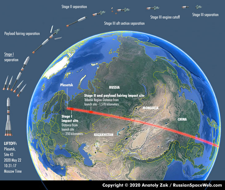
Reading the trajectory picture
The picture is a graphic of the 22 May 2020 launch (the fourth EKS satellite, Kosmos-2546) from Plesetsk, Site 43, with liftoff at 10:31:17 Moscow Time. What the graphic labels: the sequence of events along the ground track (liftoff, Stage I separation, payload fairing separation, Stage II separation, Stage III aft section separation, Stage III engine cutoff, Stage III separation); the Stage I impact site, about 350 km from the launch site; and the Stage II and payload fairing impact site in the Tobolsk Region, about 1,570 km from the launch site. The red ground track runs south-east across Russia, Kazakhstan and China. Credit: Copyright © 2020 Anatoly Zak / RussianSpaceWeb.com (see Sources). [DOCUMENTED from the image]
The ascent, step by step (from the first mission's description)
RussianSpaceWeb's account of the first mission (17 November 2015) gives the following sequence; later missions followed the same pattern, apart from small differences in timing and impact points: [DOCUMENTED / SINGLE-SOURCE]
| Time | Event |
|---|---|
| T+0 | Liftoff from Pad 4 at Site 43 with the first stage's four boosters and the core stage firing together; the rocket heads south-east along the southernmost corridor available from Plesetsk |
| About T+2 min | Four boosters separate and fall about 350 km downrange |
| About T+3 min | Payload fairing splits in two and is jettisoned; fragments fall in the West Siberian Plain |
| Under T+5 min | Third stage ignites its four-chamber RD-0124 engine through the lattice interstage; second stage separates and falls about 1,500 km downrange, north-east of Tobolsk |
| About T+9 min | Third stage releases the Fregat upper stage with the satellite on a suborbital trajectory; third-stage debris falls in the Pacific south-east of Tasmania |
| After separation | Fregat fires several times to reach the final orbit |
Fregat's job: building an elliptical orbit
A Molniya-type orbit needs a 38,500 km apogee. The Soyuz third stage cannot get there; Fregat does it in a series of burns with its restartable engine. RussianSpaceWeb's reading of the 2015 mission is that three main engine firings were probably used: [ESTIMATE based on open tracking]
After separating the satellite, Fregat typically performs a collision-avoidance manoeuvre and a de-orbit or disposal burn. NORAD detected two objects within 24 hours — the satellite (2015-066A) and the upper stage (2015-066B) — in near-identical orbits. [DOCUMENTED]
Mass, roughly
The bus dry mass is 950–1,200 kg and the payload mass 500–1,000 kg, so the dry satellite is 1.5–2.2 tonnes; with propellant, it is heavier. This sits within what a Soyuz-2.1b/Fregat can send to a Molniya orbit from Plesetsk, but the actual mass of the satellites has not been published. [ESTIMATE]
Launch-site preparation
In August 2006 Spetsstroi received a contract to build two ground-processing facilities at Plesetsk, a clean room with a climate-control chamber and a new wing of the fuelling depot with the capacity for eight fuelling cycles per year; they were reported completed in June 2015, specifically for the first EKS satellite. The fuelling depot's capacity gives an upper limit on launch cadence of eight satellites a year, well above the actual rate (a launch about once a year or less). [DOCUMENTED / SINGLE-SOURCE]
Warnings to aviation and shipping
Russia issues navigational warnings for areas where rocket stages will fall; the warnings for the 2015 launch (9–13 November) appeared in advance. Observers read these notices to guess launch dates. Official silence on the payload (the launches are announced as "launch of a Soyuz-2.1b with a spacecraft in the interests of the Ministry of Defence") is why the "believed to be EKS" qualification appears in almost every report on launches 3 to 6. [DOCUMENTED]
LAUNCH HISTORY
| No. | Designation | Name used in lists | COSPAR / NORAD | Launch (Moscow Time) | Launch vehicle | Orbit (reported) | Label |
|---|---|---|---|---|---|---|---|
| 1 | Kosmos-2510 | EKS-1 / Tundra 11L | 2015-066A / 41032 | 17 Nov 2015, 09:33:41 | Soyuz-2.1b/Fregat-M, vehicle No. 76012227 | 1,626 × 38,552 km, 63.8° | [DOCUMENTED] |
| 2 | Kosmos-2518 | EKS-2 / Tundra 12L | 2017-027A / 42719 | 25 May 2017, 09:34 | Soyuz-2.1b/Fregat-M | about 1,626 × 38,552 km, 63.4° | [DOCUMENTED / SINGLE-SOURCE] |
| 3 | Kosmos-2541 | EKS-3 / Tundra 13L | 2019-065A / 44552 | 26 Sep 2019, 10:46 | Soyuz-2.1b/Fregat, vehicle No. 78072176 | 1,646 × 38,537 km, 63.8° | [DOCUMENTED / SINGLE-SOURCE] |
| 4 | Kosmos-2546 | EKS-4 / Tundra 14L | 2020-031A / 45608 | 22 May 2020, 10:31:17 | Soyuz-2.1b/Fregat | 1,654 × about 35,800–38,000 km, 63.8° | [DOCUMENTED / SINGLE-SOURCE] |
| 5 | Kosmos-2552 | EKS-5 / Kupol No. 5 / Tundra 15L | 2021-113A / 49503 | 25 Nov 2021, 04:09:13 | Soyuz-2.1b/Fregat | 1,609 × 38,761 km, 63.8° | [DOCUMENTED / SINGLE-SOURCE] |
| 6 | Kosmos-2563 | EKS-6 / Tundra 16L | 2022-145A / 54223 | 2 Nov 2022, 09:48 | Soyuz-2.1b/Fregat | 1,596 × 38,753 km, 63.8° | [DOCUMENTED / SINGLE-SOURCE] |
Notes on the table:
Launch cadence and what it implies
Six launches in seven years is a slow cadence for a constellation that is meant to have ten HEO satellites plus GEO satellites. The long gaps (2015–2017–2019) and the interval between the last two launches reflect the factors above: delayed payloads, sanctions on electronics and competing launch priorities. With a design life of 7.5 years, the first satellite (launched 17 November 2015) reaches its design life in mid-2023; whether it continues operating is not reported. The replacement problem is therefore already present. [ESTIMATE]
CAPABILITIES — WHAT IS CLAIMED AND WHAT IS REASONABLE
| Claim | Source | Assessment | Label |
|---|---|---|---|
| Detects launch of any ballistic missile or space launch vehicle from US territory | Anonymous source in the military-industrial complex to TASS, June 2020 | Plausible for the covered region once a satellite is at its western apogee; "any" is a strong word | [SINGLE-SOURCE] |
| Uses "infrared sensors of a new generation" able to detect launches against the Earth's background and predict impact zones automatically | Same | Hendrickx judges the HEO sensor likely uses vidicon technology from the 20th century; a new-generation scanner is planned for GEO | [SINGLE-SOURCE / CONTESTED] |
| Detects ICBM, SLBM, intermediate-range, short-range missiles and space rockets | Deputy Defence Minister Krivoruchko, interview of December 2019 (later partly removed from the original site) | Medium-range and short-range missiles have shorter, dimmer burns; this is the hard case | [SINGLE-SOURCE] |
| Had detected 64 ballistic-missile launches (35 non-Russian) and 136 space launches (97 non-Russian) | Same | Counts as of late 2019 with three or four satellites | [SINGLE-SOURCE] |
| "As good as" the US SBIRS and "unique" in real-time relay to leadership | Same | Hendrickx: in numbers of sensors SBIRS far exceeds EKS; four GEO satellites with scanning and staring sensors plus three HEO-hosted scanners, plus some surviving DSP satellites; EKS had four HEO satellites then | [SINGLE-SOURCE] |
| Constellation at "minimum baseline configuration" after four satellites | RKK Energia general director, August 2020 | Four satellites ensure round-the-clock coverage of the most critical areas | [DOCUMENTED] |
| Can see launches from both the American continent and the oceans | Same | Consistent with the apogee over Greenland | [SINGLE-SOURCE] |
| Pacific coverage | — | The Pacific is the apparent coverage gap until the eastern station is ready or GEO satellites are launched | [SINGLE-SOURCE] |
Comparison with the United States SBIRS
| Aspect | Russia, EKS/Tundra | United States, SBIRS (and DSP legacy) |
|---|---|---|
| Orbits | HEO Molniya-type (6 launched); GEO planned | GEO satellites plus HEO-hosted payloads; DSP survivors |
| Sensors | Staring dual-channel telescope on HEO; scanning on planned GEO | Scanning and staring sensors on each GEO satellite |
| Constellation size | 6 launched since 2015 | Several GEO and HEO assets |
| Ground segment | Serpukhov-15; Far East station unfinished | Dedicated ground stations |
| Coverage gap | Pacific (until east station or GEO) | Global |
| Notes | Newer rate of launches is slow | Much larger sensor count |
The comparison is Hendrickx's. His summary: to match the American capability the Russians need the complete constellation of HEO and GEO satellites with a combination of staring and scanning sensors. [SINGLE-SOURCE]
LIMITS, VULNERABILITIES AND FAILURE MODES
Strategic stability
Early-warning satellites are stabilising when they are reliable: they let a state wait for confirmation instead of firing on uncertain information. They are destabilising when degraded or attacked, because a state that fears blindness may adopt a "launch on first signal" posture. The Russian programme's long gap between 2014 (no satellites) and 2020 (baseline constellation) is the period in which this concern was the sharpest, and one reason that commentators link the satellites to the debate around launch-on-warning and Perimeter. That commentary is analytic, not documented. [ESTIMATE]
THE SPACE LAYER AND THE COMMAND CHAIN
The satellites feed the main warning centre; the warning centre feeds the General Staff, now at the NDMC. For the nuclear decision chain, the leadership uses the special channels of Kazbek and the briefcase terminal Cheget; Perimeter sits behind them as a last-resort system. The article on the NDMC explains the nuclear control hall and its relationships; the article on Solnechnogorsk explains how the warning is assessed. The EKS article's contribution to that picture is the first cue. [DOCUMENTED / ESTIMATE]
See NDMC, Solnechnogorsk SPRN, Kazbek, Perimeter, Russian C3.
WHAT IS UNKNOWN
MYTHS AND OVER-READINGS
SOURCE CONFLICTS
| Topic | Source A | Source B | Treatment |
|---|---|---|---|
| Time of the second launch | 09:34 Moscow Time (RussianSpaceWeb) | 06:33 UTC (a Wikipedia list; equals 09:33 Moscow) | One-minute difference; RussianSpaceWeb used |
| Fourth satellite's apogee | 35,807 km (Wikipedia table) | about 38,000 km typical for the others | Likely early orbit; flagged |
| Who built the first two generations | NPO Lavochkin integrated (Hendrickx) | Kometa prime, as in EKS (Hendrickx) | Different roles, not a conflict |
| EKS bus | "Possibly USP/Victoria" (Wikipedia infobox) | UKP/Viktoriya (Hendrickx, RKK Energia) | Same platform name in different spellings |
| Date of the Energia contract | 18 March 2004 choice by Kometa | 31 July 2007 contract (some sources) | Hendrickx says the 2007 contract was for another project (OREST) |
| Date of final constellation | 2024 (Surovikin, 2020) | six launched by Nov 2022; no later launch found | Stated target not met in sources found |
TIMELINE
| Year | Event | Label |
|---|---|---|
| 1972 | First US-K (Oko) launch | [DOCUMENTED] |
| 1983 (26 Sep) | False alarm at Serpukhov-15; Petrov | [DOCUMENTED] |
| 1991 | US-KMO second generation introduced | [DOCUMENTED] |
| 1999 | EKS announced | [DOCUMENTED] |
| 2002 | Kometa EKS contract | [DOCUMENTED] |
| 2004 | Energia chosen | [DOCUMENTED] |
| 2010, 2012 | Last Oko satellites (Kosmos-2469, -2479) | [SINGLE-SOURCE] |
| 2014 | Oko retirement leaves no operational early-warning satellite | [SINGLE-SOURCE] |
| 2015 | First Tundra launched | [DOCUMENTED] |
| 2019 | Name "Kupol" publicly used; third Tundra | [SINGLE-SOURCE] |
| 2020 | Fourth Tundra; baseline configuration | [DOCUMENTED] |
| 2021 | Fifth Tundra | [DOCUMENTED] |
| 2022 | Sixth Tundra | [DOCUMENTED] |
GLOSSARY
| Term | Meaning |
|---|---|
| ЕКС (EKS) | Единая космическая система — Integrated (Unified) Space System |
| Купол (Kupol) | "Dome"; public name for the system |
| Тундра (Tundra), 14Ф142 | HEO early-warning satellite of EKS |
| Око (Oko) | Soviet early-warning satellite programme (US-K, US-KMO) |
| СПРН (SPRN) | System for missile attack warning |
| ГЦ РПН | Main Centre for Missile Attack Warning (Solnechnogorsk) |
| ЗМКП / ВМКП | Western / Eastern Control Station (Serpukhov-15 / Gaiter) |
| БАО | On-board detection equipment (the telescope payload) |
| БРТК | On-board radio-technical complex |
| БКУПИ | On-board control and data-transmission complex |
| АФАР | Active phased-array antenna |
| АСН | Satellite-navigation equipment (antennas) |
| УКП / Виктория | Universal Space Platform / Viktoria (the bus) |
| Бленда | Light baffle (sun shade) |
| HEO / GEO | Highly elliptical orbit / geostationary orbit |
| Molniya orbit | 12-hour, 63.4° inclined elliptical orbit |
| TDI | Time-delay integration |
| SBIRS | US Space-Based Infrared System |
ONE-PARAGRAPH SUMMARY
EKS Kupol is Russia's space layer for missile warning. Six Tundra satellites (14Ф142), launched from Plesetsk on Soyuz-2.1b/Fregat between 2015 and 2022, fly 12-hour Molniya-type orbits whose apogees hang over Greenland and the Far East. A cooled infrared staring telescope with a wide and a narrow channel looks for the plume of a launching missile; a phased-array and protected radio link carries the report to the Serpukhov-15 control station, and from there to the warning centre at Solnechnogorsk, where it is fused with the ground-radar layer and passed to the General Staff and the leadership. The satellites supplement the radars; they do not replace them, and several important facts (sensor performance, link design, constellation health) remain unpublished.
SOURCES
Labelling reminder: [DOCUMENTED], [SINGLE-SOURCE], [UNVERIFIED], [ESTIMATE] as defined at the top of the page.
RELATED ARTICLES